


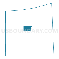
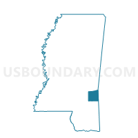
Mozingo Voting District, Wayne County, Mississippi
About
Outline

Summary
| Unique Area Identifier | 606916 |
| Name | Mozingo Voting District |
| County | Wayne County |
| State | Mississippi |
| Area (square miles) | 13.76 |
| Land Area (square miles) | 13.36 |
| Water Area (square miles) | 0.41 |
| % of Land Area | 97.03 |
| % of Water Area | 2.97 |
| Latitude of the Internal Point | 31.67732450 |
| Longtitude of the Internal Point | -88.71177560 |
Maps

Graphs
Select a template below for downloading or customizing gragh for Mozingo Voting District, Wayne County, Mississippi


Neighbors
Neighoring Voting District (by Name) Neighboring Voting District on the Map
- Beat 4 School Voting District, Wayne County, MS
- Clara Voting District, Wayne County, MS
- Waynesboro 3 Voting District, Wayne County, MS
- Waynesboro 4 Voting District, Wayne County, MS
- Waynesboro 5 Voting District, Wayne County, MS
- Yellow Creek Voting District, Wayne County, MS
Top 10 Neighboring County Subdivision (by Population) Neighboring County Subdivision on the Map
- District 5, Wayne County, MS (4,279)
- District 4, Wayne County, MS (3,958)
- District 3, Wayne County, MS (3,744)